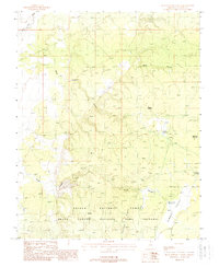
1988 Map of Buck Pasture Canyon
USGS Topo · Published 1988About this map
Kaibab National Forest dominates this Coconino County landscape, where deep drainage systems like Buck Pasture Canyon and Water Canyon carve through the plateau. In the late 1980s, this area of the Grand Canyon National Game Preserve was managed for both wildlife and limited water resources, evidenced by several small-scale catchment features. Named locations such as Wagon Hollow and Dead Man Pockets hint at the historical travel through this high-altitude terrain, while the presence of a Guzzler and remote water points like Bentonite Reservoir and Rock Canyon Reservoir illustrate the critical infrastructure required for range management. To the east, the terrain opens into Summit Valley beyond Cooper Ridge, marking a transition in the local topography near White Sage Wash.
Find a feature on this map
13 named features on this map. Tap any name to fly to it.
Don’t see what you’re looking for? This feature index may not catch every label — zoom into the map to look around manually.
Map Details
Editions of this 1988 Buck Pasture Canyon Map
This is the sole edition of this map. No revisions or reprints were ever made.
Other maps of this area

1886 · Kanab
USGS Topo · 1:250,000

1886 · Kaibab
USGS Topo · 1:250,000

1953 · Cedar City
USGS Topo · 1:250,000

1953 · Grand Canyon
USGS Topo · 1:250,000

1954 · Buckskin Gulch SE
USGS Topo · 1:24,000

1954 · Buckskin Gulch SW
USGS Topo · 1:24,000

1954 · Johnson SE
USGS Topo · 1:24,000
1954 · House Rock Spring NE
USGS Topo · 1:24,000
1954 · House Rock Spring SE
USGS Topo · 1:24,000

1954 · Buckskin Gulch
USGS Topo · 1:62,500