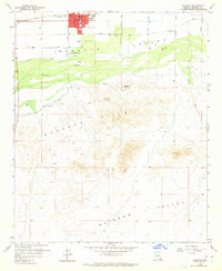
1958 Map of Buckeye
USGS Topo · Published 1964About this map
Buckeye emerges as a developing agricultural and civic hub in the late 1950s, anchored by its City Hall, Po, and a central Landing Strip. The town is situated just north of the Gila River, where the Arlington Canal and various irrigation works supported the valley's expansion. Just to the southwest lies the smaller settlement of Allenville, positioned near a Gravel Pit along the river's edge.
Find a feature on this map
26 named features on this map. Tap any name to fly to it.
Don’t see what you’re looking for? This feature index may not catch every label — zoom into the map to look around manually.
Map Details
Editions of this 1958 Buckeye Map
4 editions found

Other maps of this area

1946 · Avondale
USGS Topo · 1:62,500

1948 · Cashion
USGS Topo · 1:62,500

1951 · Mobile
USGS Topo · 1:62,500

1951 · Cotton Center
USGS Topo · 1:62,500

1954 · Phoenix
USGS Topo · 1:250,000

1957 · Phoenix
USGS Topo · 1:250,000

1957 · Valencia
USGS Topo · 1:24,000

1957 · Perryville
USGS Topo · 1:24,000

1957 · Avondale SW
USGS Topo · 1:24,000

1958 · Phoenix
USGS Topo · 1:250,000