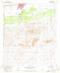
1958 Map of Buckeye
USGS Topo · Published 1972About this map
Buckeye serves as the primary hub of this desert landscape, where the agricultural order of the Buckeye Valley meets the arid expanse of the Buckeye Hills. The town's grid, including the City Hall and Post Office, is flanked by essential irrigation infrastructure like the Buckeye Canal and Arlington Canal, which divert life-giving water across the valley floor. Near the Gila River, the small settlement of Allenville sits at a lower elevation, while leisure and modern services are represented by a Drive-in Theater and Sewage Disposal plant.
Find a feature on this map
24 named features on this map. Tap any name to fly to it.
Don’t see what you’re looking for? This feature index may not catch every label — zoom into the map to look around manually.
Map Details
Editions of this 1958 Buckeye Map
4 editions found

Other maps of this area

1946 · Avondale
USGS Topo · 1:62,500

1948 · Cashion
USGS Topo · 1:62,500

1951 · Mobile
USGS Topo · 1:62,500

1951 · Cotton Center
USGS Topo · 1:62,500

1954 · Phoenix
USGS Topo · 1:250,000

1957 · Phoenix
USGS Topo · 1:250,000

1957 · Valencia
USGS Topo · 1:24,000

1957 · Perryville
USGS Topo · 1:24,000

1957 · Avondale SW
USGS Topo · 1:24,000

1958 · Phoenix
USGS Topo · 1:250,000