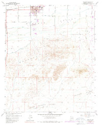
1958 Map of Buckeye
USGS Topo · Published 1988About this map
Buckeye serves as the focal point of this arid landscape, situated just north of the winding Gila River. In the late 1950s, the town center is clearly defined by the City Hall and Po, while the surrounding Buckeye Valley reveals an economy tied to water management through the Buckeye Canal and Arlington Canal. To the south, the terrain shifts dramatically from irrigated fields to the desert slopes of the Buckeye Hills, where Eagle Mtn and Mica rise above numerous mining Prospects. A fascinating historical detail is the presence of Petroglyphs recorded near a bend in the canal system, providing a link to the area's deep indigenous history. Cultural developments of the mid-century are also visible, including Allenville and a Drive-in Theater located south of the main township near the Sewage Disposal plant.
Find a feature on this map
31 named features on this map. Tap any name to fly to it.
Don’t see what you’re looking for? This feature index may not catch every label — zoom into the map to look around manually.
Map Details
Editions of this 1958 Buckeye Map
4 editions found

Other maps of this area

1946 · Avondale
USGS Topo · 1:62,500

1948 · Cashion
USGS Topo · 1:62,500

1951 · Mobile
USGS Topo · 1:62,500

1951 · Cotton Center
USGS Topo · 1:62,500

1954 · Phoenix
USGS Topo · 1:250,000

1957 · Phoenix
USGS Topo · 1:250,000

1957 · Valencia
USGS Topo · 1:24,000

1957 · Perryville
USGS Topo · 1:24,000

1957 · Avondale SW
USGS Topo · 1:24,000

1958 · Phoenix
USGS Topo · 1:250,000