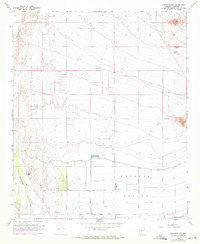
1958 Map of Buckeye NW
USGS Topo · Published 1972About this map
The Buckeye Valley landscape is defined by the transition from the arid foothills of the White Tank Mountains to the irrigated agricultural lands of the south. Central to this map is the Luke Auxiliary Field No 5, a sprawling state-owned aviation facility located just north of the Roosevelt Canal. This canal, protected by a levee, marks the boundary of the region's intensive irrigation efforts, feeding the grid of farms served by Southern Avenue and Gila and Salt River Base Line Road. To the west, the Hassayampa River cuts through the desert, while the northern reaches show industrial activity at the Blackhawk Mines. The presence of the Southern Pacific railroad at the southern edge highlights the area's role in the regional transport network during this mid-century period of development.
Find a feature on this map
32 named features on this map. Tap any name to fly to it.
Don’t see what you’re looking for? This feature index may not catch every label — zoom into the map to look around manually.
Map Details
Editions of this 1958 Buckeye NW Map
3 editions found
Other maps of this area

1954 · Phoenix
USGS Topo · 1:250,000

1957 · Phoenix
USGS Topo · 1:250,000

1957 · White Tank Mts. SE
USGS Topo · 1:24,000

1957 · Valencia
USGS Topo · 1:24,000

1957 · White Tank Mts.
USGS Topo · 1:62,500

1958 · Phoenix
USGS Topo · 1:250,000

1958 · Buckeye NW
USGS Topo · 1:24,000

1958 · Hassayampa
USGS Topo · 1:24,000

1958 · Buckeye
USGS Topo · 1:24,000

1958 · Buckeye
USGS Topo · 1:62,500