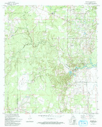
1972 Map of Buckeye
USGS Topo · Published 1993About this map
Buckeye and Deville anchor this landscape where the undulating terrain of Little Prairie and Long Prairie meets the complex drainage systems of Big Creek and Big Bayou. The area is characterized by a high concentration of family and community burial grounds, including Newell Cem, Paul Cem, Slocum Cem, and Hopewell Cem, which reflect the localized settlement patterns of eastern Rapides Parish. Religious centers like Big Island Ch and World Harvest Tabernacle served these rural clusters, while the presence of an Oil Field and several Pipeline routes highlights the region's industrial integration during the late 20th century. Along the eastern edge, the topography transitions toward the low-lying wetlands of the Big Island area, where Big Island Bayou and Coles Island Bayou intersect the Rapides Parish and Avoyelles Parish line.
Find a feature on this map
50 named features on this map. Tap any name to fly to it.
Don’t see what you’re looking for? This feature index may not catch every label — zoom into the map to look around manually.
Map Details
Editions of this 1972 Buckeye Map
2 editions found
Other maps of this area

1935 · Lecompte
USGS Topo · 1:62,500

1940 · Marksville
USGS Topo · 1:62,500

1941 · Alexandria
USGS Topo · 1:62,500

1941 · Buckeye
USGS Topo · 1:62,500

1953 · Alexandria
USGS Topo · 1:250,000

1955 · Alexandria
USGS Topo · 1:250,000

1957 · Alexandria
USGS Topo · 1:62,500

1957 · Lecompte
USGS Topo · 1:62,500

1959 · Buckeye
USGS Topo · 1:62,500
1962 · Marksville
USGS Topo · 1:62,500