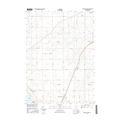
2015 Map of Buckhorn Corner
USGS Topo · Published 2015About this map
Buckhorn Corner sits at the intersection of rural thoroughfares in this portion of Dodge County, where the landscape is defined by the headwaters of several local streams. Near the northern edge of the map, the outskirts of Waupun are visible, including the vicinity of the Waupun Airport. This survey reflects the agricultural character of the region during the mid-2010s, with a dense network of country roads such as Laurel Hill Rd and Redwood Rd connecting disparate farmsteads and rural properties. The geography is notable for its numerous small wetlands and drainage patterns that feed into Mill Creek and Plum Creek, illustrating the natural water management of the Wisconsin plains.
Find a feature on this map
2 named features on this map. Tap any name to fly to it.
Don’t see what you’re looking for? This feature index may not catch every label — zoom into the map to look around manually.
Map Details
Editions of this 2015 Buckhorn Corner Map
This is the sole edition of this map. No revisions or reprints were ever made.
Other maps of this area

1955 · Beaver Dam
USGS Topo · 1:62,500

1955 · Waupun
USGS Topo · 1:62,500

1955 · Fox Lake
USGS Topo · 1:62,500

1955 · Horicon
USGS Topo · 1:62,500

1957 · Madison
USGS Topo · 1:250,000

1960 · Madison
USGS Topo · 1:250,000

1975 · Horicon NW
USGS Topo · 1:24,000

1975 · Beaver Dam NE
USGS Topo · 1:24,000

1975 · Waupun NW
USGS Topo · 1:24,000
1975 · Waupun SW
USGS Topo · 1:24,000