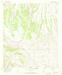
1965 Map of Buckhorn
USGS Topo · Published 1970About this map
Buckhorn serves as the primary focal point of this southwestern landscape, situated where Duck Creek and Buckhorn Creek meet. The area’s ranching and livestock history is evident through numerous water management features like Horse Lake Tank and the George Clark Tank. The terrain transitions from the alluvial plains of the creek beds to the high ground of Mud Spring Mesa and the edge of the Gila Nat For. A network of canyons, including Big Pat Canyon and Shields Canyon, carves through the landscape, illustrating the complex drainage patterns toward the larger draws. Significant landmarks such as The Dike and several isolated wells point to the essential infrastructure required for survival and industry in this arid environment during the mid-1960s.
Find a feature on this map
27 named features on this map. Tap any name to fly to it.
Don’t see what you’re looking for? This feature index may not catch every label — zoom into the map to look around manually.
Map Details
Editions of this 1965 Buckhorn Map
2 editions found
Other maps of this area

1910 · Mogollon
USGS Topo · 1:125,000

1912 · Mogollon
USGS Topo · 1:125,000

1954 · Silver City
USGS Topo · 1:250,000

1954 · Clifton
USGS Topo · 1:250,000

1957 · Clifton
USGS Topo · 1:250,000

1958 · Silver City
USGS Topo · 1:250,000

1958 · Clifton
USGS Topo · 1:250,000

1959 · Steeple Rock
USGS Topo · 1:62,500

1959 · Cliff
USGS Topo · 1:62,500

1962 · Silver City
USGS Topo · 1:250,000