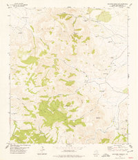
1978 Map of Buckhorn Mountain
USGS Topo · Published 1978About this map
Mount Mc Elroy dominates this 1970s landscape, featuring a modern Radio Facility amidst a network of canyons and high peaks in Jeff Davis County. The map documents the enduring infrastructure of West Texas ranching, highlighting the K C Ranch, 03 Ranch, and Shelbarger Ranch, along with numerous water sources vital for livestock in this environment. Cattle-dependent features like Leonard Camp Windmill, Gomez Windmill, and Sierra Windmill are scattered throughout the draws, linked by a system of jeep trails and pack trails. The presence of several named springs, such as Dipping Vat Spring and Shelbarger Spring, underscores the critical importance of water management in this high-altitude terrain. From the heights of Buckhorn Mountain and Indian Peak to the depths of Hell Canyon, the survey provides a detailed view of remote homesteads and topographical landmarks as they appeared decades ago.
Find a feature on this map
43 named features on this map. Tap any name to fly to it.
Don’t see what you’re looking for? This feature index may not catch every label — zoom into the map to look around manually.
Map Details
Editions of this 1978 Buckhorn Mountain Map
This is the sole edition of this map. No revisions or reprints were ever made.
Other maps of this area

1894 · Valentine
USGS Topo · 1:125,000

1894 · Fort Davis
USGS Topo · 1:125,000

1897 · Valentine
USGS Topo · 1:125,000

1897 · Fort Davis
USGS Topo · 1:125,000

1921 · Toyah
USGS Topo · 1:125,000

1928 · Kent
USGS Topo · 1:125,000

1943 · Valentine
USGS Topo · 1:125,000

1954 · Van Horn
USGS Topo · 1:250,000

1954 · Pecos
USGS Topo · 1:250,000

1954 · Fort Stockton
USGS Topo · 1:250,000