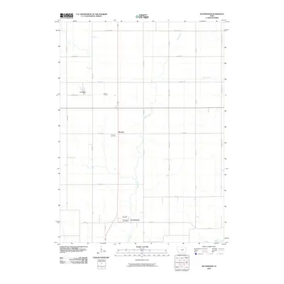
2010 Map of Buckingham
USGS Topo · Published 2010About this map
Buckingham serves as a central point of reference in this Tama County agricultural landscape, where the Buckingham Post Office and the nearby Larch Hill Cemetery reflect a long-standing rural community. The area's geography is defined by a grid of farm-to-market roads and the meandering courses of Rock Creek, Miller Creek, and Wolf Creek. Small settlements like Voorhies and Blessing punctuate the landscape, each anchored by local landmarks such as Calvary Cemetery and Blessing Cemetery. This 2010 survey illustrates the enduring rural structure of the region, showing how family heritage and community identity remain tied to these specific sections of land. The persistence of these named cemeteries and small clusters suggests a landscape where genealogical roots are deeply embedded in the township's established boundaries and drainage basins.
Find a feature on this map
33 named features on this map. Tap any name to fly to it.
Don’t see what you’re looking for? This feature index may not catch every label — zoom into the map to look around manually.
Map Details
Editions of this 2010 Buckingham Map
This is the sole edition of this map. No revisions or reprints were ever made.
Other maps of this area

1954 · Waterloo
USGS Topo · 1:250,000

1955 · Waterloo
USGS Topo · 1:250,000

1963 · Buckingham
USGS Topo · 1:24,000

1963 · Hudson
USGS Topo · 1:24,000

1963 · Waterloo South
USGS Topo · 1:24,000

1963 · Eagle Center
USGS Topo · 1:24,000

1971 · Gladbrook NE
USGS Topo · 1:24,000

1971 · Zaneta
USGS Topo · 1:24,000
1971 · Dysart
USGS Topo · 1:24,000

1971 · Traer
USGS Topo · 1:24,000