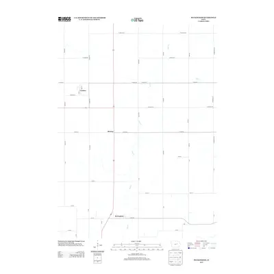
2013 Map of Buckingham
USGS Topo · Published 2013About this map
Buckingham and the nearby hamlet of Voorhies anchor this rural landscape in Tama County, surveyed in the early 2010s. The area is defined by a strictly rectilinear grid of section-line roads, such as Lincoln Rd and W Tama Rd, which partition the fertile agricultural land. The meandering course of Rock Cr and its tributary Miller Cr provide the only deviation from this geometric order, cutting through the fields toward the south. The settlement of Blessing sits at a central crossroads along the primary north-south corridor. In the northern portion of the map, the small street network of Voorhies is visible, including Main St and Brice St, illustrating the enduring footprint of these small Iowa farming communities. Modern infrastructure is represented by Co Hwy-D65, which serves as a vital connector for the residents of Buckingham.
Find a feature on this map
33 named features on this map. Tap any name to fly to it.
Don’t see what you’re looking for? This feature index may not catch every label — zoom into the map to look around manually.
Map Details
Editions of this 2013 Buckingham Map
This is the sole edition of this map. No revisions or reprints were ever made.
Other maps of this area

1954 · Waterloo
USGS Topo · 1:250,000

1955 · Waterloo
USGS Topo · 1:250,000

1963 · Buckingham
USGS Topo · 1:24,000

1963 · Hudson
USGS Topo · 1:24,000

1963 · Waterloo South
USGS Topo · 1:24,000

1963 · Eagle Center
USGS Topo · 1:24,000

1971 · Gladbrook NE
USGS Topo · 1:24,000

1971 · Zaneta
USGS Topo · 1:24,000
1971 · Dysart
USGS Topo · 1:24,000

1971 · Traer
USGS Topo · 1:24,000