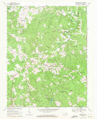
1968 Map of Buckingham
USGS Topo · Published 1971About this map
Buckingham serves as the central hub of this Piedmont landscape, situated where the Slate River and several of its tributaries, including Horsepen Creek, carve through the rolling terrain. The map documents a predominantly rural economy and community structure in the late 1960s, evidenced by the numerous country churches like Fork Union Ch and State River Ch, alongside local landmarks such as Slate River Mills. To the south, the Lee Experimental Forest encompasses a significant portion of the woodland, containing Horsepen Lake and various research tracts. Small settlements and crossroads such as Dentons Corner, Mt Rush, and Enonville are connected by a network of state routes, while a significant Pipeline corridor cuts across the eastern portion of the quadrangle. For those researching local genealogy, the distribution of small cemeteries and the presence of the Buckingham Central High Sch provide valuable points of reference.
Find a feature on this map
41 named features on this map. Tap any name to fly to it.
Don’t see what you’re looking for? This feature index may not catch every label — zoom into the map to look around manually.
Map Details
Editions of this 1968 Buckingham Map
3 editions found
Other maps of this area

1891 · Palmyra
USGS Topo · 1:125,000

1891 · Farmville
USGS Topo · 1:125,000

1892 · Buckingham
USGS Topo · 1:125,000

1892 · Appomattox
USGS Topo · 1:125,000

1893 · Farmville
USGS Topo · 1:125,000

1895 · Palmyra
USGS Topo · 1:125,000

1897 · Palmyra
USGS Topo · 1:125,000

1947 · Roanoke
USGS Topo · 1:250,000

1950 · Dillwyn
USGS Topo · 1:62,500

1958 · Farmville
USGS Topo · 1:62,500