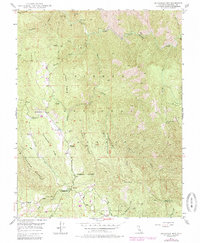
1947 Map of Buckingham Mtn
USGS Topo · Published 1985About this map
Jerseydale and Darrah serve as the primary residential anchors in this pocket of the Sierra National Forest shortly after the mid-century. The landscape is defined by a succession of high ridges, including Snyder Ridge, Footman Ridge, and Windlass Ridge, which descend toward the South Fork Merced River. The presence of the Early Mine and the Comet Mine (Aband) near Jerseydale points to the area's extraction history, while the Sawmill in Clarks Valley indicates the active timber operations of the era.
Find a feature on this map
39 named features on this map. Tap any name to fly to it.
Don’t see what you’re looking for? This feature index may not catch every label — zoom into the map to look around manually.
Map Details
Editions of this 1947 Buckingham Mtn Map
5 editions found

Other maps of this area

1897 · Yosemite
USGS Topo · 1:125,000

1900 · Yosemite
USGS Topo · 1:125,000

1903 · Yosemite
USGS Topo · 1:125,000

1909 · Yosemite
USGS Topo · 1:125,000

1912 · Mariposa
USGS Topo · 1:125,000

1947 · Mariposa
USGS Topo · 1:24,000

1947 · El Portal
USGS Topo · 1:24,000

1947 · Mariposa
USGS Topo · 1:250,000

1947 · El Portal
USGS Topo · 1:62,500

1947 · Mariposa
USGS Topo · 1:62,500