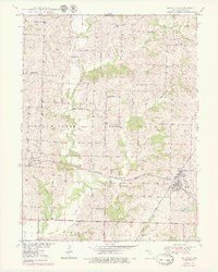
1950 Map of Bucklin
USGS Topo · Published 1979About this map
Bucklin and St Catharine anchor this survey of east-central Linn County, illustrating a landscape defined by the intersection of major rail corridors and rural community life. The Chicago Burlington And Quincy and the Atchison Topeka And Santa Fe railroads traverse the terrain, creating a transportation hub that supported the surrounding agricultural townships. The distribution of small country schools like Brownlee Sch, Oakdale Sch, and Carter Sch suggests a densely settled rural population before the consolidation of mid-century districts.
Find a feature on this map
23 named features on this map. Tap any name to fly to it.
Don’t see what you’re looking for? This feature index may not catch every label — zoom into the map to look around manually.
Map Details
Editions of this 1950 Bucklin Map
3 editions found
Other maps of this area

1946 · Brookfield
USGS Topo · 1:62,500

1948 · Brookfield
USGS Topo · 1:62,500

1949 · Rothville
USGS Topo · 1:24,000

1949 · Bucklin
USGS Topo · 1:24,000

1949 · Bucklin NW
USGS Topo · 1:24,000

1950 · Bucklin
USGS Topo · 1:24,000

1950 · New Cambria West
USGS Topo · 1:24,000

1950 · Rothville
USGS Topo · 1:24,000

1950 · Bucklin NW
USGS Topo · 1:24,000

1951 · New Boston
USGS Topo · 1:24,000