
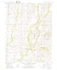
1949 Map of Rothville
USGS Topo · Published 1949About this map
Rothville serves as the primary hub in this late-1940s landscape, situated along the Atchison Topeka and Santa Fe railroad line. The settlement pattern is defined by a dense network of country schools, including Pershing Sch, Hess Sch, and Johnson Sch, which highlight the rural education infrastructure of the era. The terrain is deeply carved by the winding paths of West Yellow Creek and East Yellow Creek, which converge to form the main stem of Yellow Creek. This survey captures a rural Missouri economy in transition, where local industry is represented by a small Coal Mine and a Gravel Pit. Genealogists will find particular value in the placement of community anchors like South Eagle Ch and the Stains Cem, alongside family-named landmarks like Holloway Sch and Stains Sch.
Find a feature on this map
28 named features on this map. Tap any name to fly to it.
Don’t see what you’re looking for? This feature index may not catch every label — zoom into the map to look around manually.
Map Details
Editions of this 1949 Rothville Map
2 editions found
Other maps of this area

1946 · Brookfield
USGS Topo · 1:62,500

1948 · Brookfield
USGS Topo · 1:62,500

1949 · Mendon
USGS Topo · 1:24,000

1949 · Indian Grove
USGS Topo · 1:24,000

1949 · Sumner
USGS Topo · 1:24,000

1949 · Bucklin
USGS Topo · 1:24,000

1950 · Bucklin
USGS Topo · 1:24,000

1950 · Sumner
USGS Topo · 1:24,000

1950 · Rothville
USGS Topo · 1:24,000

1953 · Moberly
USGS Topo · 1:250,000