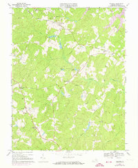
1968 Map of Buckner
USGS Topo · Published 1974About this map
The Chesapeake and Ohio railroad corridor anchors this part of Louisa County, connecting the rural communities of Fredericks Hall and Buckner. The landscape is a network of small creeks and millponds, where local hydrology supported early industry at sites like Swift Millpond and Millpond. Numerous country churches and cemeteries, including Bethpage Ch and Little River Ch, suggest a long-established pattern of rural settlement organized around these spiritual and social centers. The 1973 revisions are particularly notable for documenting the emerging shoreline of Lake Anna in the northeastern corner, marking a major transformation of the Piedmont terrain from traditional creek valleys to a large-scale reservoir system. Small crossroads like Gardners Crossroads and Threemile Corner illustrate the historic transit points that linked these farmsteads and woodlands.
Find a feature on this map
33 named features on this map. Tap any name to fly to it.
Don’t see what you’re looking for? This feature index may not catch every label — zoom into the map to look around manually.
Map Details
Editions of this 1968 Buckner Map
3 editions found
Other maps of this area

1887 · Spottsylvania
USGS Topo · 1:125,000

1890 · Goochland
USGS Topo · 1:125,000

1892 · Spottsylvania
USGS Topo · 1:125,000

1892 · Goochland
USGS Topo · 1:125,000

1942 · Mineral
USGS Topo · 1:31,680

1942 · Partlow
USGS Topo · 1:31,680

1942 · Contrary Creek
USGS Topo · 1:31,680

1942 · Pendleton
USGS Topo · 1:24,000

1942 · Buckner
USGS Topo · 1:24,000

1942 · Beaverdam
USGS Topo · 1:24,000