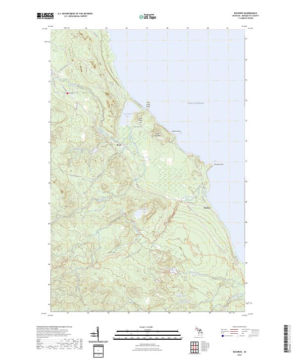
2023 Map of Buckroe
USGS Topo · Published 2023About this map
Lake Superior shoreline features dominate this northern Michigan landscape, where the rugged Upper Peninsula terrain meets the water at Saux Head Point and Thoneys Point. Inland, the 2023 survey reveals a geography defined by the winding paths of the Big Garlic River and Little Garlic River, which feed into the lake through a series of coastal marshes and lowlands. Small settlements such as Birch and Buckroe are connected by a network of county roads, while the North Country National Scenic Trail traverses the southern half of the quadrangle. The presence of Gold Mine Rd hints at the region's historical industrial interests, contrasting with the preserved natural areas surrounding Saux Head Lake and Blemhuber Lake. The map details a transition from the elevated heights of Garlic Mountain down to the secluded basins of Echo Lake and Dollar Lake.
Find a feature on this map
41 named features on this map. Tap any name to fly to it.
Don’t see what you’re looking for? This feature index may not catch every label — zoom into the map to look around manually.
Map Details
Editions of this 2023 Buckroe Map
This is the sole edition of this map. No revisions or reprints were ever made.
Other maps of this area

1907 · Marquette
USGS Topo · 1:62,500

1953 · Marquette NW
USGS Topo · 1:24,000

1953 · Negaunee
USGS Topo · 1:24,000

1954 · Negaunee SW
USGS Topo · 1:24,000
1954 · Marquette
USGS Topo · 1:24,000

1954 · Negaunee
USGS Topo · 1:62,500

1954 · Big Bay
USGS Topo · 1:62,500

1954 · Marquette
USGS Topo · 1:62,500

1958 · Marquette
USGS Topo · 1:250,000

1960 · Marquette
USGS Topo · 1:250,000