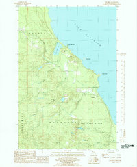
1985 Map of Buckroe
USGS Topo · Published 1985About this map
The Lake Superior shoreline north of Marquette is defined by a series of rocky points and river mouths where the Garlic River and Little Garlic River meet the water. This 1985 survey captures a landscape dominated by the Escanaba River State Forest, showing a network of small water bodies like Blemhuber Lake, Echo Lake, and Dollar Lake tucked between the peaks. The presence of an Old Railroad Grade and a Sawmill on Birch Creek points to the area's history of timber extraction, while small settlements like Buckroe, Birch, and Loma Farm suggest the sparse, localized development of the era. Higher elevations such as Garlic Mountain and Saux Head Hill overlook prominent coastal features like Saux Head Point and the small Garlic Island, illustrating the primitive and largely undeveloped nature of the Michigan Upper Peninsula coastline at this time.
Find a feature on this map
27 named features on this map. Tap any name to fly to it.
Don’t see what you’re looking for? This feature index may not catch every label — zoom into the map to look around manually.
Map Details
Editions of this 1985 Buckroe Map
This is the sole edition of this map. No revisions or reprints were ever made.
Other maps of this area

1907 · Marquette
USGS Topo · 1:62,500

1953 · Marquette NW
USGS Topo · 1:24,000

1953 · Negaunee
USGS Topo · 1:24,000

1954 · Negaunee SW
USGS Topo · 1:24,000
1954 · Marquette
USGS Topo · 1:24,000

1954 · Negaunee
USGS Topo · 1:62,500

1954 · Big Bay
USGS Topo · 1:62,500

1954 · Marquette
USGS Topo · 1:62,500

1958 · Marquette
USGS Topo · 1:250,000

1960 · Marquette
USGS Topo · 1:250,000