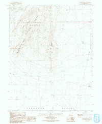
1991 Map of Buckskin Hills
USGS Topo · Published 1991About this map
Conger Range and the Buckskin Hills define this arid landscape in eastern Millard County, where the high ridges of the Great Basin meet the expansive Ferguson Desert. The map documents a rugged terrain shaped by prominent landforms such as the Middle Point of the Buckskins and the Long Point of the Buckskins, which stretch into the valley floor. Human activity in this remote region is sparse but clearly mapped through vital water resources including the Little Valley Well, a Water Tank, and various guzzlers and cisterns. Infrastructure is limited to the Cross Road and a network of unimproved trails and transmission lines that cross the desert floor, alongside a small Gravel Pit indicative of local material extraction. This 1991 provisional edition provides a detailed record of the topography and essential desert waypoints before the turn of the twenty-first century.
Find a feature on this map
16 named features on this map. Tap any name to fly to it.
Don’t see what you’re looking for? This feature index may not catch every label — zoom into the map to look around manually.
Map Details
Editions of this 1991 Buckskin Hills Map
This is the sole edition of this map. No revisions or reprints were ever made.
Other maps of this area

1908 · Fish Springs
USGS Topo · 1:250,000

1910 · Fish Springs
USGS Topo · 1:250,000

1953 · Richfield
USGS Topo · 1:250,000

1953 · Delta
USGS Topo · 1:250,000

1958 · Richfield
USGS Topo · 1:250,000

1958 · Delta
USGS Topo · 1:250,000

1960 · Conger Range
USGS Topo · 1:62,500

1960 · Burbank Hills
USGS Topo · 1:62,500

1960 · Crystal Peak
USGS Topo · 1:62,500

1960 · Conger Mountain
USGS Topo · 1:62,500