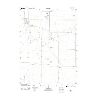
2012 Map of Buda
USGS Topo · Published 2012About this map
Sheffield and Buda anchor this central Illinois landscape, reflecting the grid-based settlement and agricultural development of Bureau County. The terrain is defined by the headwaters of several drainages, including the Fork Spoon River and Coal Cr, which cut through the fertile prairie. The distribution of small burial sites such as Saint Patrick Cem, Wood Family Cem, and Fifield Cem points to the early family-based and parish-centered history of the region. A dense network of county roads, including Co RD-1400 and Co RD-800, connects the primary settlements to smaller locales like Langley and Burnett. The presence of Gravel Hill provides a rare topographic marker in a region primarily dedicated to row-crop farming, while the arrangement of streets in the town centers shows the enduring influence of the rail lines that historically spurred local growth.
Find a feature on this map
77 named features on this map. Tap any name to fly to it.
Don’t see what you’re looking for? This feature index may not catch every label — zoom into the map to look around manually.
Map Details
Editions of this 2012 Buda Map
This is the sole edition of this map. No revisions or reprints were ever made.
Other maps of this area

1921 · Buda
USGS Topo · 1:62,500

1923 · Buda
USGS Topo · 1:62,500

1929 · Annawan
USGS Topo · 1:62,500

1932 · Annawan
USGS Topo · 1:62,500

1933 · Camp Grove
USGS Topo · 1:48,000

1944 · Kewanee
USGS Topo · 1:62,500

1945 · Bradford
USGS Topo · 1:62,500

1958 · Aurora
USGS Topo · 1:250,000

1961 · Aurora
USGS Topo · 1:250,000
1983 · Buda NE
USGS Topo · 1:24,000