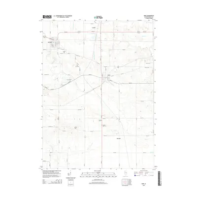
2015 Map of Buda
USGS Topo · Published 2015About this map
Sheffield and Buda anchor this Bureau County landscape, which is defined by a grid of agricultural section roads and the winding path of Coal Cr. The area is notably dense with small, localized cemeteries that speak to the long-standing family lineages and community centers of the region, including the Wood Family Cem and Fifield Cem. The northern portion of the map is dominated by the linear drainage of the Devils Slough Ditch near the settlement of Langley. This survey captures the rural character of the Illinois prairie, showing the transition from the concentrated street grids of the towns to the scattered farmsteads and landmarks like Gravel Hill. Waterways such as Pond Cr and the E Fork Spoon River suggest the natural drainage patterns that the local ditch systems were built to manage.
Find a feature on this map
53 named features on this map. Tap any name to fly to it.
Don’t see what you’re looking for? This feature index may not catch every label — zoom into the map to look around manually.
Map Details
Editions of this 2015 Buda Map
This is the sole edition of this map. No revisions or reprints were ever made.
Other maps of this area

1921 · Buda
USGS Topo · 1:62,500

1923 · Buda
USGS Topo · 1:62,500

1929 · Annawan
USGS Topo · 1:62,500

1932 · Annawan
USGS Topo · 1:62,500

1933 · Camp Grove
USGS Topo · 1:48,000

1944 · Kewanee
USGS Topo · 1:62,500

1945 · Bradford
USGS Topo · 1:62,500

1958 · Aurora
USGS Topo · 1:250,000

1961 · Aurora
USGS Topo · 1:250,000
1983 · Buda NE
USGS Topo · 1:24,000