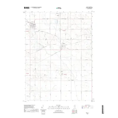
2018 Map of Buda
USGS Topo · Published 2018About this map
Sheffield and Buda anchor this Bureau County landscape, which reflects a long-established grid of rural roads and agrarian parcels. The area is notable for its numerous small burial grounds and family plots, including Wood Family Cem and the larger Sheffield Cem, providing a detailed record for genealogical research. The terrain is marked by a network of drainage features like Devils Slough Ditch and natural watercourses such as Coal Cr and the E Fork Spoon River, which influence the local topography. To the south, the small settlement of Burnett and landmarks like Gravel Hill sit among the rolling fields. The map preserves the street plans of the primary villages, showing E Railroad St in Sheffield and Grant St in Buda, illustrating the intersection of rail-era town planning with the surrounding township and range survey system.
Find a feature on this map
65 named features on this map. Tap any name to fly to it.
Don’t see what you’re looking for? This feature index may not catch every label — zoom into the map to look around manually.
Map Details
Editions of this 2018 Buda Map
This is the sole edition of this map. No revisions or reprints were ever made.
Other maps of this area

1921 · Buda
USGS Topo · 1:62,500

1923 · Buda
USGS Topo · 1:62,500

1929 · Annawan
USGS Topo · 1:62,500

1932 · Annawan
USGS Topo · 1:62,500

1933 · Camp Grove
USGS Topo · 1:48,000

1944 · Kewanee
USGS Topo · 1:62,500

1945 · Bradford
USGS Topo · 1:62,500

1958 · Aurora
USGS Topo · 1:250,000

1961 · Aurora
USGS Topo · 1:250,000
1983 · Buda NE
USGS Topo · 1:24,000