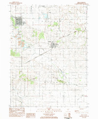
1983 Map of Buda
USGS Topo · Published 1984About this map
Buda and Sheffield serve as the primary rail hubs for this Bureau County landscape, where the Chicago and Northwestern and Burlington Northern lines intersect amidst a well-ordered agricultural grid. The transition from the flatlands of Concord to the more varied terrain of Macon township is punctuated by Gravel Hill and the headwaters of the Spoon River. To the north, the Hennepin Canal Parkway State Park and Devils Slough Ditch illustrate the region's legacy of drainage and canal infrastructure.
Find a feature on this map
27 named features on this map. Tap any name to fly to it.
Don’t see what you’re looking for? This feature index may not catch every label — zoom into the map to look around manually.
Map Details
Editions of this 1983 Buda Map
This is the sole edition of this map. No revisions or reprints were ever made.
Other maps of this area

1921 · Buda
USGS Topo · 1:62,500

1923 · Buda
USGS Topo · 1:62,500

1929 · Annawan
USGS Topo · 1:62,500

1932 · Annawan
USGS Topo · 1:62,500

1933 · Camp Grove
USGS Topo · 1:48,000

1944 · Kewanee
USGS Topo · 1:62,500

1945 · Bradford
USGS Topo · 1:62,500

1958 · Aurora
USGS Topo · 1:250,000

1961 · Aurora
USGS Topo · 1:250,000
1983 · Buda NE
USGS Topo · 1:24,000