
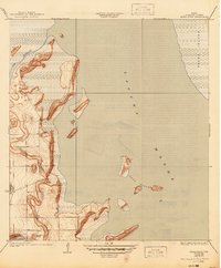
1935 Map of Buena Vista
USGS Topo · Published 1935About this map
Buena Vista Ranch sits at the edge of a coastal landscape defined by shifting sands and intricate waterways as documented by County Engineer W. O. Washington. The expansive Laguna Madre dominates the eastern half of the sheet, buffered by the barrier dunes of Padre Island. This coastal geography reveals a complex system of shallow inlets and brackish basins, including the winding Resaca de los Cuates and the broad Laguna Atascosa. The survey, which utilized aerial photography in the early 1930s, captures the isolated nature of the South Texas coastline before modern development. Notable landmarks such as Horse Island and the cluster of Three Islands stand out as prominent terrain features within the lagoon, marking a period when these shores were largely used for ranching and maritime navigation rather than recreation.
Find a feature on this map
8 named features on this map. Tap any name to fly to it.
Don’t see what you’re looking for? This feature index may not catch every label — zoom into the map to look around manually.
Map Details
Editions of this 1935 Buena Vista Map
2 editions found
Other maps of this area

1929 · La Coma
USGS Topo · 1:24,000

1929 · Buena Vista
USGS Topo · 1:24,000

1930 · Padre Island No. 1
USGS Topo · 1:24,000

1930 · La Leona
USGS Topo · 1:24,000

1930 · Padre Island No. 2
USGS Topo · 1:24,000

1930 · Laguna Atascosa
USGS Topo · 1:24,000

1934 · La Coma
USGS Topo · 1:31,680

1935 · Padre Island No 1
USGS Topo · 1:31,680

1935 · Padre Island NO. 2
USGS Topo · 1:31,680

1936 · La Leona
USGS Topo · 1:31,680