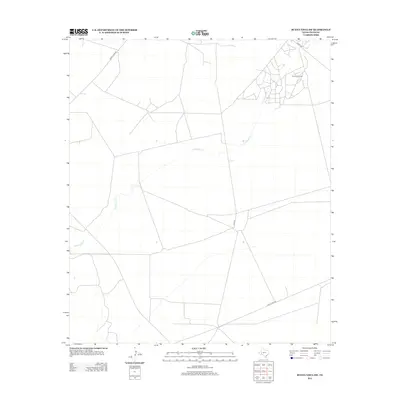
2012 Map of Buena Vista SW
USGS Topo · Published 2012About this map
The Fromme Oil Field dominates the northeastern landscape of this Pecos County region, where a dense network of service roads reflects the intense energy extraction activities of the early 21st century. The terrain is defined by the winding path of Comanche Cr, which meanders across the arid basin, crossing under several significant transportation corridors. Infrastructure supporting the local industry is evident in the layout of Gulf Plant Rd and Gulf Rd, which connect the industrial sites to the broader region. While the landscape is largely characterized by this petroleum economy, older routes like Buena Vista Rd and Owego Rd maintain the rural connectivity of this West Texas territory, providing a clear record of how industrial development has integrated into the traditional ranching geography.
Find a feature on this map
6 named features on this map. Tap any name to fly to it.
Don’t see what you’re looking for? This feature index may not catch every label — zoom into the map to look around manually.
Map Details
Editions of this 2012 Buena Vista SW Map
This is the sole edition of this map. No revisions or reprints were ever made.
Other maps of this area

1921 · Fort Stockton
USGS Topo · 1:62,500

1923 · Fort Stockton
USGS Topo · 1:62,500

1928 · Comanche Spring
USGS Topo · 1:125,000

1954 · Pecos
USGS Topo · 1:250,000

1954 · Fort Stockton
USGS Topo · 1:250,000

1957 · Pecos
USGS Topo · 1:250,000

1958 · Fort Stockton
USGS Topo · 1:250,000

1970 · East Mesa
USGS Topo · 1:24,000
1970 · Saddle Butte
USGS Topo · 1:24,000
1970 · Fort Stockton East
USGS Topo · 1:24,000