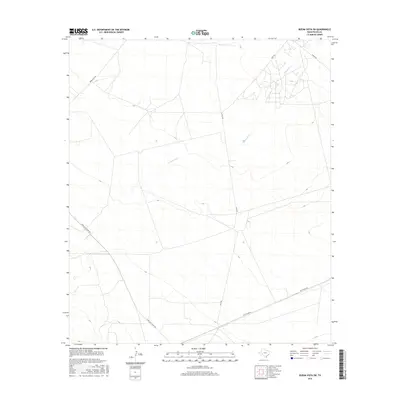
2016 Map of Buena Vista SW
USGS Topo · Published 2016About this map
Comanche Cr winds through this arid Pecos County landscape, providing the primary drainage for a region defined by its industrial and energy-sector infrastructure. The presence of the Texas Gulf Plant Rd and Gulf Plant Rd suggests the historical significance of chemical or mineral extraction in this part of West Texas. These routes, along with Buena Vista Rd, create a specialized transportation network serving local industry rather than dense residential settlement. The survey illustrates how the rugged terrain and intermittent waterways of the Trans-Pecos dictated the placement of these essential access roads, which connect distant plant sites and ranching land to the broader regional grid. Researchers will find a clear record of the intersection between natural geography and the heavy industrial footprints that have shaped the county's modern economy.
Find a feature on this map
6 named features on this map. Tap any name to fly to it.
Don’t see what you’re looking for? This feature index may not catch every label — zoom into the map to look around manually.
Map Details
Editions of this 2016 Buena Vista SW Map
This is the sole edition of this map. No revisions or reprints were ever made.
Other maps of this area

1921 · Fort Stockton
USGS Topo · 1:62,500

1923 · Fort Stockton
USGS Topo · 1:62,500

1928 · Comanche Spring
USGS Topo · 1:125,000

1954 · Pecos
USGS Topo · 1:250,000

1954 · Fort Stockton
USGS Topo · 1:250,000

1957 · Pecos
USGS Topo · 1:250,000

1958 · Fort Stockton
USGS Topo · 1:250,000

1970 · East Mesa
USGS Topo · 1:24,000
1970 · Saddle Butte
USGS Topo · 1:24,000
1970 · Fort Stockton East
USGS Topo · 1:24,000