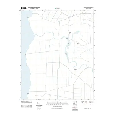
2011 Map of Buffalo City
USGS Topo · Published 2011About this map
Buffalo City and the coastal lowlands of Dare County are defined by a complex web of waterways and drainage canals in this 2011 survey. Situated along the eastern bank of the Alligator River, the area is dominated by the winding path of Milltail Creek, which snakes through the wetlands past Buzzard Roost and Raccoon Point. The map reveals a rigid grid of drainage features and rural roads, such as Milltail Rd and Dry Ridge North Rd, which contrast with the natural curvature of Sawyer Lake and the irregular shoreline. This landscape reflects the intersection of managed coastal land and the natural aquatic environment. Locations like Beach Land Landing and Sandy Ridge provide specific points of reference for understanding the historical and environmental layout of this peninsula before the terrain transitions into the broad waters of the river.
Find a feature on this map
21 named features on this map. Tap any name to fly to it.
Don’t see what you’re looking for? This feature index may not catch every label — zoom into the map to look around manually.
Map Details
Editions of this 2011 Buffalo City Map
This is the sole edition of this map. No revisions or reprints were ever made.
Other maps of this area

1943 · Columbia
USGS Topo · 1:125,000

1943 · Roanoke Island
USGS Topo · 1:125,000

1953 · Engelhard NW
USGS Topo · 1:24,000

1953 · Buffalo City
USGS Topo · 1:24,000

1953 · Fairfield NE
USGS Topo · 1:24,000

1953 · East Lake SE
USGS Topo · 1:24,000

1953 · Manns Harbor
USGS Topo · 1:24,000
1953 · East Lake
USGS Topo · 1:24,000

1953 · Engelhard NE
USGS Topo · 1:24,000

1953 · Frying Pan
USGS Topo · 1:24,000