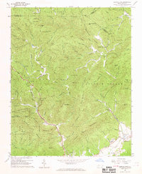
1967 Map of Buffalo Cove
USGS Topo · Published 1968About this map
Patterson and the winding course of the Yadkin River anchor this mid-century view of the Blue Ridge foothills. The landscape is defined by its deep coves and narrow ridges, where small communities like Buffalo Cove, Finley, and Legerwood are linked by rural roads and mountain gaps. The presence of several early milling operations, including Lowder Mill, Moody Mill, and Rader Mill, suggests a local economy still closely tied to its watercourses and timber. Along the slopes of the Blue Ridge, the Pisgah National Forest covers much of the high ground, punctuated by landmarks such as White Rock Mtn and Raven Rock Knob. Local life is further evidenced by several country churches, such as Bethany Ch and the Chapel of Rest, alongside the Patterson Sch, which served as a focal point for the Yadkin Valley residents during this era of topographic mapping.
Find a feature on this map
104 named features on this map. Tap any name to fly to it.
Don’t see what you’re looking for? This feature index may not catch every label — zoom into the map to look around manually.
Map Details
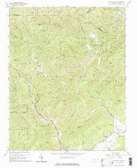
Editions of this 1967 Buffalo Cove Map
2 editions found
Other maps of this area

1889 · Wilkesboro
USGS Topo · 1:125,000

1891 · Wilkesboro
USGS Topo · 1:125,000

1893 · Cranberry
USGS Topo · 1:125,000

1895 · Hickory
USGS Topo · 1:125,000

1895 · Cranberry
USGS Topo · 1:125,000

1899 · Cranberry
USGS Topo · 1:125,000

1902 · Cranberry
USGS Topo · 1:125,000

1905 · Morganton
USGS Topo · 1:125,000

1934 · Boone
USGS Topo · 1:24,000

1936 · Blowing Rock
USGS Topo · 1:48,000