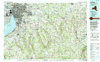
1984 Map of Buffalo
USGS Topo · Published 1994About this map
Buffalo and its industrial waterfront dominate the eastern shore of Lake Erie in this mid-1980s topographic portrait of Western New York. The map details the dense urban core extending from Buffalo Outer Harbor through Kenmore and Tonawanda, while the Niagara River separates the mainland from Grand Island. Transportation corridors such as the New York State Thruway and the Aurora Expressway connect the city to outlying towns like East Aurora, Warsaw, and Batavia.
Find a feature on this map
71 named features on this map. Tap any name to fly to it.
Don’t see what you’re looking for? This feature index may not catch every label — zoom into the map to look around manually.
Map Details
Editions of this 1984 Buffalo Map
2 editions found
Other maps of this area

1894 · Buffalo
USGS Topo · 1:62,500

1894 · Niagara Falls
USGS Topo · 1:62,500

1896 · Niagara Falls
USGS Topo · 1:62,500

1897 · Tonawanda
USGS Topo · 1:62,500

1897 · Albion
USGS Topo · 1:62,500

1897 · Medina
USGS Topo · 1:62,500

1897 · Lockport
USGS Topo · 1:62,500

1899 · Silver Creek
USGS Topo · 1:62,500

1899 · Niagara
USGS Topo · 1:125,000

1899 · Brockport
USGS Topo · 1:62,500