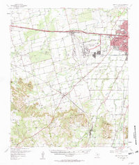
1957 Map of Buffalo Gap
USGS Topo · Published 1958About this map
Dyess Air Force Base dominates the center of this mid-century Taylor County landscape, highlighting the era's military expansion adjacent to a growing Abilene. The map details the transition from the urban sprawl of Abilene, featuring McMurry College and Bonham Sch, to the prominent topographic rise of the Callahan Divide. This physical barrier separates the rolling plains to the north from the high ridges like Buzzard Mountain and Round Top Mountain to the south.
Find a feature on this map
47 named features on this map. Tap any name to fly to it.
Don’t see what you’re looking for? This feature index may not catch every label — zoom into the map to look around manually.
Map Details
Editions of this 1957 Buffalo Gap Map
2 editions found

Other maps of this area

1890 · Abilene
USGS Topo · 1:125,000

1891 · Anson
USGS Topo · 1:125,000

1892 · Abilene
USGS Topo · 1:125,000

1893 · Roby
USGS Topo · 1:125,000

1893 · Anson
USGS Topo · 1:125,000

1893 · Sweetwater
USGS Topo · 1:125,000

1954 · Big Spring
USGS Topo · 1:250,000

1954 · Abilene
USGS Topo · 1:250,000

1957 · Hawley
USGS Topo · 1:62,500

1957 · Merkel
USGS Topo · 1:62,500