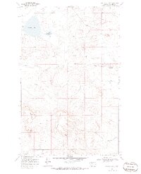
1968 Map of Buffalo Lake
USGS Topo · Published 1986About this map
The Blackfeet Indian Reservation in northwestern Montana is defined here by a series of prominent buttes and the drainage networks that carve the plains. Buffalo Lake and Little Buffalo Lake anchor the northern landscape, providing vital water sources in this high-altitude terrain. The map documents a sparsely settled ranching environment in the late 1960s, evidenced by the Branderval Ranch and scattered wells. The topography is dominated by dramatic elevation changes at Chalk Butte and the long spine of Horsethief Ridge, which separates the seasonal flows of Big Crown Coulee and Little Rock Coulee. This survey illustrates the intricate relationship between the natural water runoff, such as South Fork Little Rock Coulee, and the grazing lands utilized by residents within the reservation boundaries during this era.
Find a feature on this map
13 named features on this map. Tap any name to fly to it.
Don’t see what you’re looking for? This feature index may not catch every label — zoom into the map to look around manually.
Map Details
Editions of this 1968 Buffalo Lake Map
2 editions found
Other maps of this area

1911 · Blackfoot
USGS Topo · 1:125,000

1960 · Cut Bank
USGS Topo · 1:250,000

1963 · Cut Bank
USGS Topo · 1:250,000

1964 · Cut Bank
USGS Topo · 1:250,000

1968 · Buffalo Lake
USGS Topo · 1:24,000

1968 · Rimrock Butte
USGS Topo · 1:24,000
1968 · Love Rock
USGS Topo · 1:24,000

1968 · Rocky Buttes
USGS Topo · 1:24,000
1968 · Fort Piegan
USGS Topo · 1:24,000
1968 · Del Bonita
USGS Topo · 1:24,000