
1970 Map of Buffalo NE
USGS Topo · Published 1973About this map
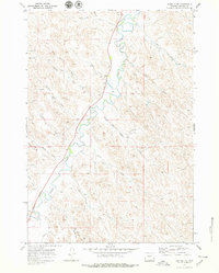
Clear Creek serves as the primary artery for this corner of Johnson County, cutting a winding path through a landscape defined by an intricate network of named draws and irrigation infrastructure. The map reveals the critical importance of water management in the region during the early 1970s, evidenced by the Big Bonanza Ditch and the Des Moines Ditch that parallel the creek's course. These man-made channels highlight the transition from natural drainage to managed agricultural land.
Find a feature on this map
23 named features on this map. Tap any name to fly to it.
Don’t see what you’re looking for? This feature index may not catch every label — zoom into the map to look around manually.
Map Details
Editions of this 1970 Buffalo NE Map
2 editions found
Other maps of this area

1900 · Fort McKinney
USGS Topo · 1:125,000

1903 · Fort McKinney
USGS Topo · 1:125,000

1909 · Sheridan
USGS Topo · 1:125,000

1911 · Sheridan
USGS Topo · 1:125,000

1955 · Sheridan
USGS Topo · 1:250,000

1958 · Sheridan
USGS Topo · 1:250,000

1962 · Sheridan
USGS Topo · 1:250,000
1970 · Buffalo
USGS Topo · 1:24,000
1970 · Horse Hill
USGS Topo · 1:24,000
1970 · Buffalo SE
USGS Topo · 1:24,000