
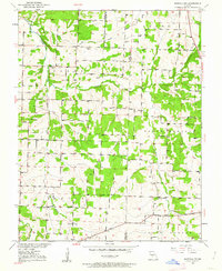
1950 Map of Buffalo NW
USGS Topo · Published 1963About this map
The borderlands of Polk and Dallas Counties are defined by the winding course of Lindley Creek and its many tributaries, such as Jordan Creek and Brush Creek. This mid-century survey reveals a rural landscape deeply rooted in its local institutions, evidenced by the distribution of country schoolhouses like Carter Sch, Concord Sch, and Crescent Sch. These schools, spaced for a walking population, along with houses of worship such as Lindley Ch and Reynolds Chapel, served as the primary social hubs for the farming families in Greene, North Benton, and South Benton townships. The map records important genealogical landmarks, including Bradbears Cem and Ragsdale Cem, providing a precise spatial record of the communities in this portion of Missouri before later 20th-century consolidation changed the rural social structure.
Find a feature on this map
20 named features on this map. Tap any name to fly to it.
Don’t see what you’re looking for? This feature index may not catch every label — zoom into the map to look around manually.
Map Details
Editions of this 1950 Buffalo NW Map
2 editions found
Other maps of this area

1884 · Bolivar
USGS Topo · 1:125,000

1892 · Bolivar
USGS Topo · 1:125,000

1949 · Sentinel
USGS Topo · 1:24,000

1950 · Sentinel
USGS Topo · 1:24,000

1950 · Polk
USGS Topo · 1:24,000

1950 · Urbana
USGS Topo · 1:24,000

1951 · Buffalo NW
USGS Topo · 1:24,000

1951 · Urbana
USGS Topo · 1:24,000

1951 · Polk
USGS Topo · 1:24,000
1951 · Hermitage
USGS Topo · 1:62,500