
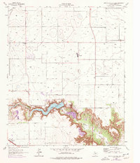
1965 Map of Buffalo Springs Lake
USGS Topo · Published 1966About this map
Yellow House Canyon carves a deep path across the high plains of West Texas, dominated by the waters of Buffalo Springs Lake and Benson Lake. Created behind the McMillan Dam, these reservoirs provide a sharp contrast to the surrounding agricultural grid. The landscape is characterized by a dense network of water wells and oil wells, connected by locally named arteries like Bear Farm Road and Walters Road. Small communities and waypoints such as Roosevelt and Canyon serve as local hubs, with the High Sch at Roosevelt anchoring the rural population.
Find a feature on this map
23 named features on this map. Tap any name to fly to it.
Don’t see what you’re looking for? This feature index may not catch every label — zoom into the map to look around manually.
Map Details
Editions of this 1965 Buffalo Springs Lake Map
2 editions found
Other maps of this area

1954 · Lubbock
USGS Topo · 1:250,000

1956 · New Deal
USGS Topo · 1:24,000

1957 · Lubbock East
USGS Topo · 1:24,000

1957 · New Home
USGS Topo · 1:62,500

1957 · Lubbock
USGS Topo · 1:62,500

1965 · Acuff
USGS Topo · 1:24,000

1965 · Slaton
USGS Topo · 1:24,000

1965 · Slaton NE
USGS Topo · 1:24,000

1965 · Idalou
USGS Topo · 1:24,000

1965 · Lorenzo
USGS Topo · 1:24,000