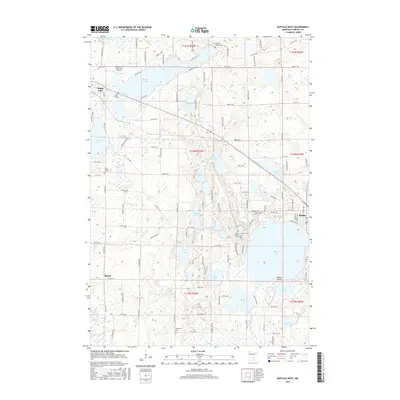
2016 Map of Buffalo West
USGS Topo · Published 2016About this map
Glacial lakes and small-town agricultural centers define this portion of Wright County, where the city of Buffalo and the village of Maple Lake anchor the landscape. The Soo Line railroad cuts a diagonal path through the terrain, historically connecting these rural communities to broader regional markets. The map reveals a dense distribution of water bodies, including the significant Buffalo Lake, Deer Lake, and Maple Lake, which are interspersed with numerous smaller basins like Albert Lake and Berthiaume Lake. Local history and genealogy researchers will find multiple religious landmarks, notably the clusters of cemeteries such as Saint Francis Cem, Saint Timothy Cem, and Old Saint Timothy Cem. The presence of the Maple Lake Municipal Airport and a grid of county roads like Co Rd 37 NW reflects a developed infrastructure that supports the area's mix of lakeside residential life and farming.
Find a feature on this map
118 named features on this map. Tap any name to fly to it.
Don’t see what you’re looking for? This feature index may not catch every label — zoom into the map to look around manually.
Map Details
Editions of this 2016 Buffalo West Map
This is the sole edition of this map. No revisions or reprints were ever made.
Other maps of this area

1951 · Annandale
USGS Topo · 1:62,500

1953 · Saint Cloud
USGS Topo · 1:250,000

1953 · Stillwater
USGS Topo · 1:250,000

1955 · Stillwater
USGS Topo · 1:250,000

1957 · Saint Cloud
USGS Topo · 1:250,000

1958 · Stillwater
USGS Topo · 1:250,000

1958 · Saint Cloud
USGS Topo · 1:250,000

1958 · Buffalo
USGS Topo · 1:62,500

1958 · Cokato
USGS Topo · 1:62,500

1961 · Silver Creek
USGS Topo · 1:24,000