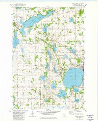
1981 Map of Buffalo West
USGS Topo · Published 1982About this map
The townships of Marysville, Chatham, and Maple Lake converge in this detailed look at Wright County’s glacial landscape in the early 1980s. The region is defined by a dense concentration of water bodies, notably the large Maple Lake and the western reaches of Buffalo Lake, with smaller basins like Abbie Lake, North Twin Lake, and Berthiaume Lake scattered throughout. This topography heavily influenced local infrastructure, as seen in the winding path of the Old Railroad Grade and the placement of the Maple Lake Municipal Airport. Several historic parish cemeteries, including St Timothy Cem, Old St Timothy Cem, and St Francis Cem, are documented here, providing valuable reference points for genealogists. To the south, the Crow River cuts through the township boundaries near the Marysville Cem, while to the north, the Maple Lake State Wildlife Management Area preserves the wetland character of the basin.
Find a feature on this map
58 named features on this map. Tap any name to fly to it.
Don’t see what you’re looking for? This feature index may not catch every label — zoom into the map to look around manually.
Map Details
Editions of this 1981 Buffalo West Map
This is the sole edition of this map. No revisions or reprints were ever made.
Other maps of this area

1951 · Annandale
USGS Topo · 1:62,500

1953 · Saint Cloud
USGS Topo · 1:250,000

1953 · Stillwater
USGS Topo · 1:250,000

1955 · Stillwater
USGS Topo · 1:250,000

1957 · Saint Cloud
USGS Topo · 1:250,000

1958 · Stillwater
USGS Topo · 1:250,000

1958 · Saint Cloud
USGS Topo · 1:250,000

1958 · Buffalo
USGS Topo · 1:62,500

1958 · Cokato
USGS Topo · 1:62,500

1961 · Silver Creek
USGS Topo · 1:24,000