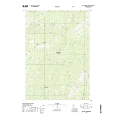
2020 Map of Bull Creek Hot Springs
USGS Topo · Published 2020About this map
The Middle Fork Payette River carves a deep valley through this portion of the Boise National Forest, serving as the primary drainage for a network of high-elevation tributaries. This 2020 survey details the complex topography of the North Fork Range and East Mtn, where elevations rise sharply from the riverbanks. A notable geothermal feature, Bull Creek Hot Springs, is located along the eastern slopes of the river canyon. The map reveals the infrastructure of forest management and access, including the Silver Creek Lookout and high-altitude crossings like Silver Creek Summit. The drainage patterns are intricate, with specifically named branches such as Horsethief Clear Creek and Sixteen To One feeding into the main river system. Transportation is limited to rugged routes like Middle Fork Payette Cutoff and Liggett Creek Way, reflecting the area's primary use for timber management and wilderness recreation.
Find a feature on this map
45 named features on this map. Tap any name to fly to it.
Don’t see what you’re looking for? This feature index may not catch every label — zoom into the map to look around manually.
Map Details
Editions of this 2020 Bull Creek Hot Springs Map
This is the sole edition of this map. No revisions or reprints were ever made.
Other maps of this area

1909 · Garden Valley
USGS Topo · 1:125,000

1953 · Boiling Springs
USGS Topo · 1:62,500

1953 · Deadwood Reservoir
USGS Topo · 1:62,500

1954 · Gold Fork
USGS Topo · 1:62,500

1954 · Warm Lake
USGS Topo · 1:62,500

1957 · Challis
USGS Topo · 1:250,000

1960 · Challis
USGS Topo · 1:250,000

1963 · Challis
USGS Topo · 1:250,000

1982 · Pistol Creek
USGS Topo · 1:100,000

1982 · Deadwood River
USGS Topo · 1:100,000