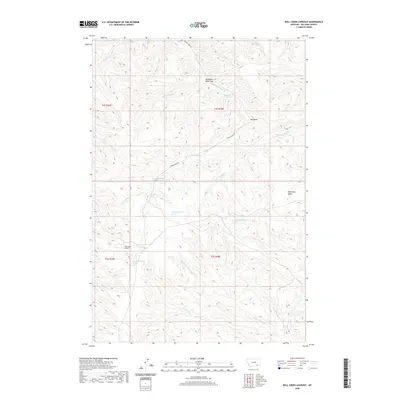
2020 Map of Bull Creek Lookout
USGS Topo · Published 2020About this map
Bull Creek Lookout anchors the high ground of this Big Horn County landscape, overlooking a complex system of drainage headwaters. The terrain is defined by the branching tributaries of the N Fork Bull Cr, Middle Fork Bull Cr, and S Fork Bull Cr as they cut through the elevation south of Big Bend. To the north, the Hardrobe Water Gap provides a notable geological break in the ridgelines near Hardrobe Spring. Transportation in this area remains concentrated along the corridor of Muddy Creek Rd, which follows the path of the W Fork Muddy Cr. The presence of several springs, including Killsnight Spring, suggests a landscape where water sources were critical markers for navigation and survival in the basin country east of the Horse Cr drainage.
Find a feature on this map
28 named features on this map. Tap any name to fly to it.
Don’t see what you’re looking for? This feature index may not catch every label — zoom into the map to look around manually.
Map Details
Editions of this 2020 Bull Creek Lookout Map
This is the sole edition of this map. No revisions or reprints were ever made.
Other maps of this area

1954 · Hardin
USGS Topo · 1:250,000

1957 · Hardin
USGS Topo · 1:250,000

1958 · Hardin
USGS Topo · 1:250,000

1958 · Painted Hill
USGS Topo · 1:24,000

1958 · Bull Creek Lookout
USGS Topo · 1:24,000

1958 · Busby
USGS Topo · 1:24,000

1958 · Birdseye Spring
USGS Topo · 1:24,000

1958 · Lame Deer
USGS Topo · 1:24,000
1967 · Cook Creek Butte
USGS Topo · 1:24,000

1967 · Kirby
USGS Topo · 1:24,000