
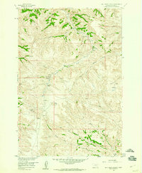
1958 Map of Bull Creek Lookout
USGS Topo · Published 1960About this map
Bull Creek Lookout anchors this 1958 survey of the Montana high country, where the landscape is defined by the complex drainage systems of Muddy Creek and Bull Creek. The topography reveals a network of seasonal water sources and springs, such as Killweight Spring and Hardrobe Spring, which were vital waypoints in this arid environment. The presence of Brown Camp and several primitive transportation routes, including a Jeep Trail, suggests a region utilized for ranching or land management in the mid-20th century.
Find a feature on this map
26 named features on this map. Tap any name to fly to it.
Don’t see what you’re looking for? This feature index may not catch every label — zoom into the map to look around manually.
Map Details
Editions of this 1958 Bull Creek Lookout Map
2 editions found
Other maps of this area

1954 · Hardin
USGS Topo · 1:250,000

1957 · Hardin
USGS Topo · 1:250,000

1958 · Hardin
USGS Topo · 1:250,000

1958 · Painted Hill
USGS Topo · 1:24,000

1958 · Busby
USGS Topo · 1:24,000

1958 · Birdseye Spring
USGS Topo · 1:24,000

1958 · Lame Deer
USGS Topo · 1:24,000
1967 · Cook Creek Butte
USGS Topo · 1:24,000

1967 · Kirby
USGS Topo · 1:24,000
1967 · Taintor Desert
USGS Topo · 1:24,000