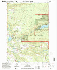
1997 Map of Bull Run
USGS Topo · Published 1999About this map
The Bull Run Watershed Management Unit dominates the central landscape of this 1990s survey, a strictly protected area that secures the regional water supply. This hydrological focus is visible through an intricate network of infrastructure, including the Bull Run Reservoir No 2, the Flume leading from the Bull Run River, and the Marmot Dam situated along the Sandy River. The map reveals the intersection of industrial utility and recreational or community sites, such as Camp Namanu and Camp Howard, positioned near the western boundary. Settled areas like Aims and Cherryville anchor the periphery, while the Devils Backbone ridge provides a prominent natural landmark. For researchers, the inclusion of the Bull Run (Site) and various gaging stations illustrates the long-standing management of these river systems before modern alterations to the hydraulic landscape.
Find a feature on this map
43 named features on this map. Tap any name to fly to it.
Don’t see what you’re looking for? This feature index may not catch every label — zoom into the map to look around manually.
Map Details
Editions of this 1997 Bull Run Map
This is the sole edition of this map. No revisions or reprints were ever made.
Other maps of this area

1911 · Boring
USGS Topo · 1:48,000

1914 · Boring
USGS Topo · 1:62,500

1916 · Estacada
USGS Topo · 1:125,000

1918 · Troutdale
USGS Topo · 1:62,500

1934 · Troutdale
USGS Topo · 1:48,000

1940 · Boring
USGS Topo · 1:62,500

1941 · Camas
USGS Topo · 1:62,500

1942 · Camas
USGS Topo · 1:62,500

1948 · Vancouver
USGS Topo · 1:250,000

1950 · Vancouver
USGS Topo · 1:250,000