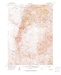
1956 Map of Bull Run
USGS Topo · Published 1963About this map
Silver Creek Ranch and Columbia Ranch anchor a landscape defined by ranching and mining in mid-century Elko County. The high peaks of the Bull Run Mountains and the Independence Mountains frame a series of rugged canyons and drainage basins, including the notable Bull Run Basin and Wilson Canyon. These peaks reach significant elevations, with Porter Peak and Pennsylvania Hill dominating the skyline.
Find a feature on this map
79 named features on this map. Tap any name to fly to it.
Don’t see what you’re looking for? This feature index may not catch every label — zoom into the map to look around manually.
Map Details
Editions of this 1956 Bull Run Map
3 editions found
Other maps of this area

1936 · Mountain City
USGS Topo · 1:62,500

1939 · Owyhee
USGS Topo · 1:62,500

1940 · Mountain City
USGS Topo · 1:62,500

1942 · Owyhee
USGS Topo · 1:62,500

1955 · McDermitt
USGS Topo · 1:250,000

1955 · Wells
USGS Topo · 1:250,000

1956 · Tuscarora
USGS Topo · 1:62,500

1956 · Mt. Blitzen
USGS Topo · 1:62,500

1956 · Bull Run
USGS Topo · 1:62,500

1956 · Wild Horse
USGS Topo · 1:62,500