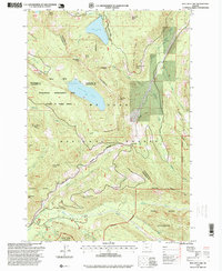
1997 Map of Bull Run Lake
USGS Topo · Published 1999About this map
Mt Hood National Forest dominates this landscape at the intersection of Hood River, Multnomah, and Clackamas counties. The topography is defined by significant volcanic peaks and glacial hydrology, most notably Bull Run Lake and Lost Lake. The former sits within the Bull Run Watershed Management Unit, a restricted-access area vital for regional water supply. Further east, the Lost Lake Resort represents a focal point for recreation at the foot of Lost Lake Butte. The map details a network of high-elevation paths, including the Pacific Crest National Scenic Trail and the Timberline Trail, which navigate ridges like Yocum Ridge and Butcher Knife Ridge. In the lower elevations, industrial activities are noted through the Chitwood Quarry and the Old Maid Sand Pit near the Sandy River.
Find a feature on this map
60 named features on this map. Tap any name to fly to it.
Don’t see what you’re looking for? This feature index may not catch every label — zoom into the map to look around manually.
Map Details
Editions of this 1997 Bull Run Lake Map
This is the sole edition of this map. No revisions or reprints were ever made.
Other maps of this area

1924 · Mount Hood
USGS Topo · 1:125,000

1926 · Hood River
USGS Topo · 1:125,000

1927 · Mount Hood
USGS Topo · 1:125,000

1929 · Hood River
USGS Topo · 1:125,000

1953 · The Dalles
USGS Topo · 1:250,000

1956 · The Dalles
USGS Topo · 1:250,000

1957 · The Dalles
USGS Topo · 1:250,000

1957 · Bonneville Dam
USGS Topo · 1:62,500

1957 · Hood River
USGS Topo · 1:62,500
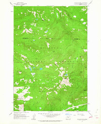
1962 · Hickman Butte
USGS Topo · 1:24,000