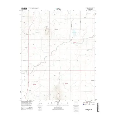
2013 Map of Bulldog Mesa
USGS Topo · Published 2013About this map
Bulldog Mesa and Mesa Redonda dominate this portion of Quay County, New Mexico, where the high desert landscape is defined by its drainage basins and isolated ranching outposts. This 2013 survey reveals a traditional land-use pattern where water management is paramount, centered on Regulator Reservoir Number 2 and the seasonal flows of Plaza Larga Cr and Apodaca Cr. The map preserves the locations of generational family properties, including Stallard Ranch, Parker Ranch, and Fife Ranch, which are connected by a gridded network of rural routes such as Quay Road 58 and NM-209. For genealogists and local historians, the inclusion of Newhome Cem and Apodaca Cem provides critical points for tracing the community's ancestral ties to this arid ranching frontier.
Find a feature on this map
36 named features on this map. Tap any name to fly to it.
Don’t see what you’re looking for? This feature index may not catch every label — zoom into the map to look around manually.
Map Details
Editions of this 2013 Bulldog Mesa Map
This is the sole edition of this map. No revisions or reprints were ever made.
Other maps of this area

1930 · Tucumcari
USGS Topo · 1:125,000

1954 · Tucumcari
USGS Topo · 1:250,000

1954 · Clovis
USGS Topo · 1:250,000

1958 · Clovis
USGS Topo · 1:250,000

1958 · Tucumcari
USGS Topo · 1:250,000

1967 · Liberty Mesa
USGS Topo · 1:24,000

1967 · Tucumcari
USGS Topo · 1:24,000

1968 · Bulldog Mesa
USGS Topo · 1:24,000

1968 · Lesbia
USGS Topo · 1:24,000
1968 · Briscoe Ranch
USGS Topo · 1:24,000