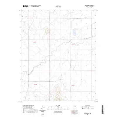
2023 Map of Bulldog Mesa
USGS Topo · Published 2023About this map
Bulldog Mesa and Mesa Redonda dominate this high-plains landscape in Quay County, where the terrain is defined by the drainage networks of Plaza Larga Creek and Apodaca Creek. The map documents a sparsely settled ranching or agricultural region organized by a strict grid of rural routes, including Quay Road 53 and Quay Road AJ. Evidence of early community life is preserved at Newhome Cem in the northeast and Apodaca Cem further south. Water management is a central theme of the land's utility, marked by features such as the Savage Lateral and Regulator Reservoir Number 2. These structures, alongside several smaller unnamed catchments, highlight the critical nature of irrigation and water storage in this semi-arid environment, providing a detailed look at the infrastructure required to sustain the local area.
Find a feature on this map
23 named features on this map. Tap any name to fly to it.
Don’t see what you’re looking for? This feature index may not catch every label — zoom into the map to look around manually.
Map Details
Editions of this 2023 Bulldog Mesa Map
This is the sole edition of this map. No revisions or reprints were ever made.
Other maps of this area

1930 · Tucumcari
USGS Topo · 1:125,000

1954 · Tucumcari
USGS Topo · 1:250,000

1954 · Clovis
USGS Topo · 1:250,000

1958 · Clovis
USGS Topo · 1:250,000

1958 · Tucumcari
USGS Topo · 1:250,000

1967 · Liberty Mesa
USGS Topo · 1:24,000

1967 · Tucumcari
USGS Topo · 1:24,000

1968 · Bulldog Mesa
USGS Topo · 1:24,000

1968 · Lesbia
USGS Topo · 1:24,000
1968 · Briscoe Ranch
USGS Topo · 1:24,000