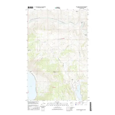
2017 Map of Bullfrog Mountain
USGS Topo · Published 2017About this map
Similkameen River flows through the northern reaches of this Okanogan County landscape, winding past Shankers Bend below the slopes of Kruger Mountain. The terrain is defined by significant elevations, including Bullfrog Mountain and Ellemeham Mtn, which overlook a network of high-country roads such as Ellemeham Mtn Rd and Log Camp Rd. For genealogists and local historians, the Golden Cem provides a specific point of interest in the southeastern quadrant, situated near Spring Lake and the northern tip of Wannacut Lake. The map also traces the Pacific NW National Scenic Trail as it traverses the western side of the quadrangle, passing near Palmer Lake and following the course of Loomis Oroville Rd.
Find a feature on this map
27 named features on this map. Tap any name to fly to it.
Don’t see what you’re looking for? This feature index may not catch every label — zoom into the map to look around manually.
Map Details
Editions of this 2017 Bullfrog Mountain Map
This is the sole edition of this map. No revisions or reprints were ever made.
Other maps of this area

1902 · Osoyoos
USGS Topo · 1:125,000

1904 · Osoyoos
USGS Topo · 1:125,000

1906 · Chopaka
USGS Topo · 1:125,000

1954 · Okanogan
USGS Topo · 1:250,000

1956 · Loomis
USGS Topo · 1:62,500

1957 · Oroville
USGS Topo · 1:62,500

1958 · Okanogan
USGS Topo · 1:250,000

1975 · Oroville NW
USGS Topo · 1:24,000
1981 · Nighthawk
USGS Topo · 1:24,000
1982 · Enterprise
USGS Topo · 1:24,000