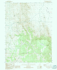
1991 Map of Bullgrass Knoll
USGS Topo · Published 1991About this map
The Confusion Range dominates this portion of Millard County, defining a landscape of high ridges and deep drainages in the West Desert. This 1991 provisional survey documents the transition from the upland heights of Bullgrass Knoll and the Horse Heaven plateau down into the arid floor of the Tule Valley (Depression). The terrain is carved by numerous significant incisions including Kings Canyon, Cat Canyon, and Blackham Canyon, illustrating the complex erosional patterns of the Great Basin. Small-scale industrial activity is evidenced by a Gravel Pit located near the mouth of the canyons, while 4WD tracks represent the primary means of navigating the high passes and remote basins like Little Horse Heaven and King Cove. The map serves as a detailed record of the physical geography of the basin-and-range province before modern land-use changes.
Find a feature on this map
16 named features on this map. Tap any name to fly to it.
Don’t see what you’re looking for? This feature index may not catch every label — zoom into the map to look around manually.
Map Details
Editions of this 1991 Bullgrass Knoll Map
This is the sole edition of this map. No revisions or reprints were ever made.
Other maps of this area

1908 · Fish Springs
USGS Topo · 1:250,000

1910 · Fish Springs
USGS Topo · 1:250,000

1953 · Richfield
USGS Topo · 1:250,000

1953 · Delta
USGS Topo · 1:250,000

1958 · Richfield
USGS Topo · 1:250,000

1958 · Delta
USGS Topo · 1:250,000

1960 · Notch Peak
USGS Topo · 1:62,500

1960 · Crystal Peak
USGS Topo · 1:62,500

1960 · Conger Mountain
USGS Topo · 1:62,500

1960 · The Barn
USGS Topo · 1:62,500