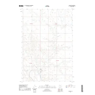
2017 Map of Bullhead
USGS Topo · Published 2017About this map
The settlement of Bullhead sits prominently at the confluence of the Grand River and Rock Cr, serving as a central point in this northern South Dakota landscape. The community layout features streets with historically significant names such as Rain In The Face Ave and Hunk Papa Ave, reflecting the local heritage. To the east of the town center, the Saint Aloysius Cem and a Po are clearly marked, providing specific points of interest for genealogists and local historians. The surrounding terrain is defined by a network of seasonal watercourses including Iron Dog Cr and Stink Cr, which feed into the primary river system. Transportation through this part of Corson County is facilitated by Bia Hwy 21 and Bullhead Rd, which connect the scattered homesteads and topographical features across the sections.
Find a feature on this map
19 named features on this map. Tap any name to fly to it.
Don’t see what you’re looking for? This feature index may not catch every label — zoom into the map to look around manually.
Map Details
Editions of this 2017 Bullhead Map
This is the sole edition of this map. No revisions or reprints were ever made.
Other maps of this area

1953 · McIntosh
USGS Topo · 1:250,000

1956 · Bullhead
USGS Topo · 1:24,000

1956 · Little Eagle NW
USGS Topo · 1:24,000

1956 · Miscol
USGS Topo · 1:24,000

1956 · Bullhead SW
USGS Topo · 1:24,000

1956 · Miscol NE
USGS Topo · 1:24,000

1958 · McIntosh
USGS Topo · 1:250,000

1971 · McLaughlin SW
USGS Topo · 1:24,000
1971 · Maple Leaf
USGS Topo · 1:24,000

1972 · Walker
USGS Topo · 1:24,000