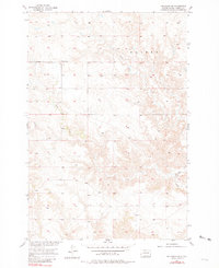
1956 Map of Bullhead SW
USGS Topo · Published 1981About this map
Iron Dog Creek and Stink Creek wind through the township of Walker in this mid-century survey of Corson County. The landscape is defined by its drainage patterns and the isolated Grant Sch, a rural landmark serving the community during the development of the Missouri River Basin. While the map was published in the early 1980s, its data is grounded in aerial photography from 1950 and field checks in 1956, preserving the mid-twentieth-century character of this Northern Plains region. The topography illustrates the subtle but significant elevation changes across the open country, providing a clear record of the area's rural infrastructure before modern shifts in agricultural and community settlement.
Find a feature on this map
4 named features on this map. Tap any name to fly to it.
Don’t see what you’re looking for? This feature index may not catch every label — zoom into the map to look around manually.
Map Details
Editions of this 1956 Bullhead SW Map
2 editions found
Other maps of this area

1953 · McIntosh
USGS Topo · 1:250,000

1956 · Black Horse NE
USGS Topo · 1:24,000

1956 · Bullhead
USGS Topo · 1:24,000

1956 · Miscol
USGS Topo · 1:24,000

1956 · Bullhead SW
USGS Topo · 1:24,000

1956 · Miscol NE
USGS Topo · 1:24,000

1958 · McIntosh
USGS Topo · 1:250,000

1972 · Walker
USGS Topo · 1:24,000
1972 · McIntosh SE
USGS Topo · 1:24,000

1972 · McIntosh
USGS Topo · 1:24,000