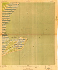
1919 Map of Bulls Island
USGS Topo · Published 1919About this map
Bulls Island is the centerpiece of this 1918 coastal survey, revealing the intricate geography of the Charleston County shoreline before mid-century changes. The map documents a landscape defined by an complex network of tidal waterways, including Belvedere Creek, Vanderhorst Creek, and the wide expanse of Bulls Bay. For local historians and researchers, the island's interior is detailed with the routes of Old Fort Road and Lighthouse Road, which lead toward the shoreline's notable landmarks. A significant historical marker is the Bulls Bay L H (Abandoned) lighthouse on the island's northeastern tip, alongside the site of an Old Fort. The map's bathymetric details and vegetation shading distinguish between woods, brush, and marsh, providing a clear record of the barrier island's environment at the close of the Great War.
Find a feature on this map
18 named features on this map. Tap any name to fly to it.
Don’t see what you’re looking for? This feature index may not catch every label — zoom into the map to look around manually.
Map Details
Editions of this 1919 Bulls Island Map
3 editions found
Other maps of this area

1919 · Capers Island
USGS Topo · 1:21,120

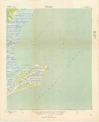
1919 · Bulls Island
USGS Topo · 1:21,120

1919 · Sewee Bay
USGS Topo · 1:21,120

1942 · Mc Clellanville
USGS Topo · 1:24,000

1943 · Capers Island
USGS Topo · 1:24,000

1943 · Sewee Bay
USGS Topo · 1:24,000

1943 · Bulls Island
USGS Topo · 1:24,000

1943 · Awendaw
USGS Topo · 1:24,000

1943 · Ocean Bay
USGS Topo · 1:24,000

1948 · James Island
USGS Topo · 1:250,000