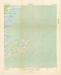
1919 Map of Bulls Island
USGS Topo · Published 1919About this map
Bulls Island is the centerpiece of this coastal survey, revealing a landscape defined by intricate maritime waterways and early transportation routes. Just after the First World War, the island's interior was traversed by Old Fort Road, Lighthouse Road, and Avenue Road, indicating an organized presence near the Old Fort and the now-silent Bulls Bay L H (Abandoned). The surrounding marshes and sounds are deeply etched by tidal systems including Sewee Creek, Bulls Creek, and several family-named tributaries like Vanderhorst Creek and Belvedere Creek. This topographic record, produced by the Corps of Engineers, U.S. Army, provides an exact inventory of the barrier island's ridges and sloughs before modern changes, documenting the transition from a working maritime landscape to a preserved natural area.
Find a feature on this map
18 named features on this map. Tap any name to fly to it.
Don’t see what you’re looking for? This feature index may not catch every label — zoom into the map to look around manually.
Map Details
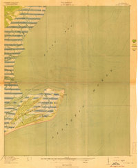
Editions of this 1919 Bulls Island Map
3 editions found
Other maps of this area

1919 · Capers Island
USGS Topo · 1:21,120

1919 · Bulls Island
USGS Topo · 1:21,120

1919 · Sewee Bay
USGS Topo · 1:21,120

1942 · Mc Clellanville
USGS Topo · 1:24,000

1943 · Capers Island
USGS Topo · 1:24,000

1943 · Sewee Bay
USGS Topo · 1:24,000

1943 · Bulls Island
USGS Topo · 1:24,000

1943 · Awendaw
USGS Topo · 1:24,000

1943 · Ocean Bay
USGS Topo · 1:24,000

1948 · James Island
USGS Topo · 1:250,000